By Bill Kearney and Angie DiMichele
South Florida Sun Sentinel breaking news online news
(South Florida Sun Sentinel)— Tropical Storm Alberto, the first named storm of 2024 hurricane season, has formed in the Gulf of Mexico and is headed for the coast of Mexico.
As of 2 p.m. Eastern time Wednesday, the storm was 295 miles south-southeast of Brownsville, Texas, traveling west at 9 mph, with maximum sustained winds of 40 mph.
Separate from Alberto, forecasters also are watching two other potential systems, one in the Gulf, and one east of the Bahamas, which could affect Florida.
Forecasters expect Alberto to strengthen slightly Wednesday or Wednesday night before making landfall sometime early Thursday morning, south of the U.S. border with Mexico.
Once inland, the storm should weaken quickly, and likely dissipate over Mexico on Thursday or Thursday night.
Alberto is a large, slow-moving tropical storm, with tropical-storm-force winds extending outward up to 415 miles north of the center.
The National Hurricane Center has issued a tropical storm warning that stretches 400 or so miles, from the Mexico border north along the Gulf Coast to near Houston.
breaking news online news
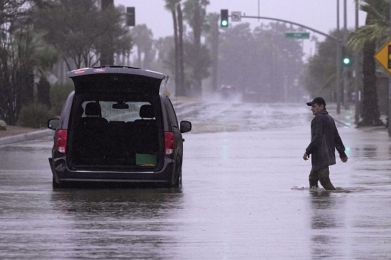
On Wednesday morning, the storm was causing coastal flooding near Galveston, Texas, 500 miles away from its likely landfall in Mexico. Storm surge there is expected to reach 2 to 4 feet, depending on tide. There was even some street flooding in Louisiana.
(Please click onto the image of the cat to hear Classic Rock & Oldies)

Forecasters urged people to not focus solely on the storm’s forecast track.
The hurricane center has expanded the tropical storm warning north, to San Luis Pass near Houston.
“The disturbance is very large with rainfall, coastal flooding, and wind impacts likely to occur far from the center along the coasts of Texas and northeastern Mexico,” the hurricane center said.
Inland in Mexico and South Texas, rainfall could be significant and potentially dangerous, given the mountainous terrain in some of the region.
Rainfall totals of 5 to 10 inches across northeast Mexico into South Texas are possible, with maximum totals of 15 inches. Flash flooding and mudslides are potential hazards.
Additional systems
As of 2 p.m. Wednesday, a disturbance in the same area of the Gulf of Mexico as Alberto had a 30% chance of forming in the next seven days. It is expected to move slowly northwest and develop over the southwestern Gulf over the weekend.
Meanwhile, forecasters are watching an area of storminess several hundred miles east of the central Bahamas and could approach the southern U.S. East Coast, potentially including Florida, late this week.
It has a 20% chance of development over the next two days, with some slow development possible thereafter while the system moves westward or west-northwestward.
breaking news online news
The systems is likely to stay north of South Florida, and impact coastal areas farther up the coast.
The 2024 hurricane season, which officially began June 1, is expected to be extremely active. Monday’s watch was the first of the 2024 hurricane season, which forecasters say will be a strong one.

In its annual May outlook, the National Oceanic and Atmospheric Administration said that the 2024 hurricane season has an 85% chance of being above normal, with 17 to 25 named storms with minimum sustained winds of 39 mph, and eight to 13 hurricanes. An average year has 14 named storms and seven hurricanes.
In addition, NOAA has forecast four to seven major hurricanes for 2024, meaning those that are Category 3 or above.
Experts at Colorado State University stated in their 2024 forecast that the U.S. East Coast, including Florida, had a 34% chance of a major hurricane making landfall this year. The average from 1880-2020 was 21%.
Forecasters say that the record-warm water temperatures that now cover much of the Atlantic Ocean will continue into peak hurricane season from August to October. That warm water fuels hurricanes. By early June, the tropical Atlantic was already as hot as it usually is in mid-August — peak hurricane season.
Hurricane season officially ends Nov. 30.
(Sun Sentinel staff writer Robin Webb contributed to this report.)
©2024 South Florida Sun Sentinel. Visit at sun-sentinel.com. Distributed by Tribune Content Agency, LLC.
breaking news online news